See the Route Map at the bottom of this page!
COVID and some big Real Life happenings combined to keep your YBR team off the backroads for a while! But we’re finally back with a day trip to one of our favorite places and two new ones!
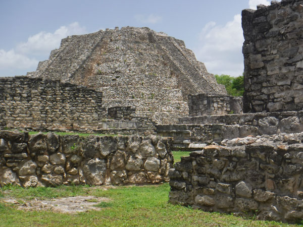
We started with a highway trip to Mayapan, our favorite Maya archaeolgical site. Mayapan really does have some of everything in a very close by and compact space — pyramids, columns, a round observatory-style structure and other interesting buildings. You’ll find Mayapan explored in detail in other stories on our YBR site, so we’ll skip the details here.
From the Archaeological Zone, it’s just a few minutes drive north up the highway to the turnoff for Telchaquillo. This is a sweet little village with the requisite small church. Drive into centro and then head east from the square towards Pixya. Most of this back road is in good shape, but it’s always good to watch for potholes!
Pixya is a small, pretty disappointing village. We are usually impressed with the neatness and cleanliness of remote Yucatan villages, but not this one. Just pass through onto the only road east. It becomes a bumpy dirt road; drive carefully!
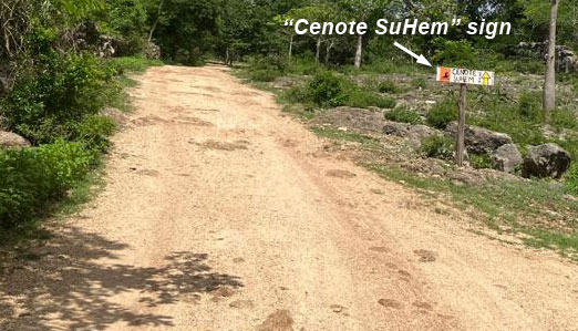
You’ll see a small sign to Cenote Su-Hem as you leave town, and there will be more as you follow the road.
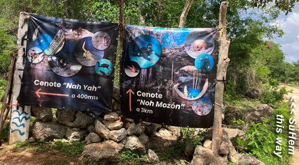
You’ll reach a fork with big signs pointing to two cenotes; we continued straight to visit Su-Hem first.
(But we will return this way and take that road to the left to Nah Yah later.)
Cenote Su-Hem has minimal infrastructure, but there is a baño/changing room building by the parking area. Entrance fee is MX$70 per person regardless of age or residency, and a life jacket (not required but advisable) costs MX$30. (We bring our own.) Leave as much of your stuff in your car as you can; depending on how many people are down below there may not be room to leave it on the platform.
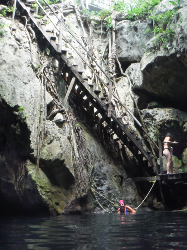
It’s a short walk to the cenote, which is about half open to the sky. The stairs are steep but were recently maintained as of mid-July 2023; there were no problems going down or up, just go slowly!
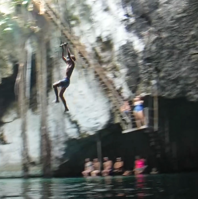
Because the light from the Sun does reach the water, it is not as crystal-clear as some other cenotes we’ve visited. But it is very clean and fine for swimming or floating around. NOTE that there are NO shallow areas in this cenote, so you really will want the lifejacket unless you’re a natural floater. (Your YBR Webmaster sinks like a stone.) Because it is so deep, there are a couple of rope swings installed high on the walls. So if you or your kids are into swinging high and plunging into the water, this cenote is for you!
There were a few other people here during our visit, but there’s a good chance that you can often have the whole place to yourself.
We left Su-Hem in our swimsuits and drove the short distance back to the fork, then made the right turn to visit Cenote Nah-Yah. This will be of special interest to any SCUBA divers in our group; I had no idea there were diving cenotes this close to Merida!
A large sign placed by Diving Yucatan shows you the two submerged tunnels that extend out from the Cenote. One of their groups was just leaving when we arrived and everyone was speaking English, so if you’ve ever thought about doing some serious cave diving, visit their Website https://www.divingyucatan.com ! (NOTE from their Website: “In order to dive with us in any cenote in Yucatan, you are required to have an international diver certification.”)
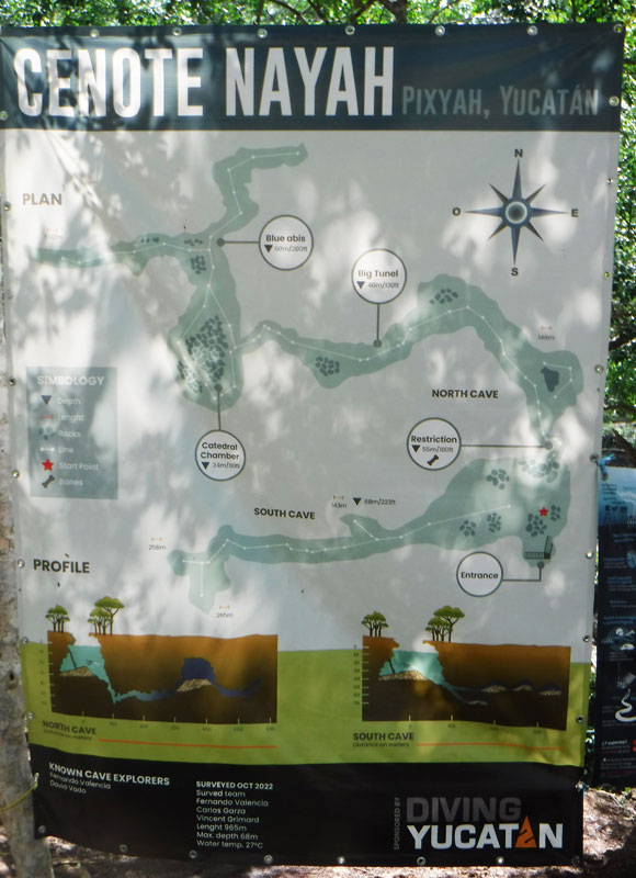
Entry fee/life vest rental is the same, $70 and $30. Nah-Yah has an even smaller baño than Su-Hem, and that’s about it for infrastructure. A steep stair takes you down to the water; there is a wood platform where you can put your stuff if it’s not crowded. (But given the steep stairway, we advise not carrying a bag down there anyway.)
Nah-Yah has a much smaller opening to the sky, and the water is extremely clear and has a breathtaking shade of blue. Again, there are no shallow areas to rest (although there is a small cave that a few people can climb into; you see that in one of the photos).
THE DRIVE HOME (see the map below)
We decided to avoid the Merida/Cancun Highway (which was choked with traffic on the way down due to Maya Train bridge construction at Teya), and found a route which we will use from now on to reach the Mayapan region. After getting back to the main Merida/Chetumal Highway at Telchaquillo, we headed north only as far as Acanceh and made the left (actually a U-turn and right) to Timucuy. This road is narrow but in excellent condition. Follow it thru Timucuy (which is bigger than we thought!) to Tekik de Regil. Turn north toward San Pedro Chimay. A few km after SPC you merge into a road; the other fork going south heads to Dzoyaxché and other destinations you’ll find here in YBR.
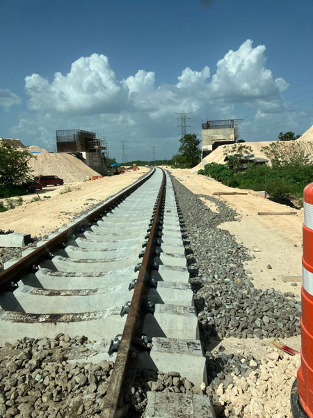
(Yes, you cross Maya Train construction here too! But the traffic is a tiny fraction of what you have on the Cancun highway. Still, you may want to check the Traffic layer of Google Maps. This photo was taken at the crossing north of San Pedro Chimay.)
Now it’s just northbound to the Periferico and (to the beach towns) counter-clockwise around and home!
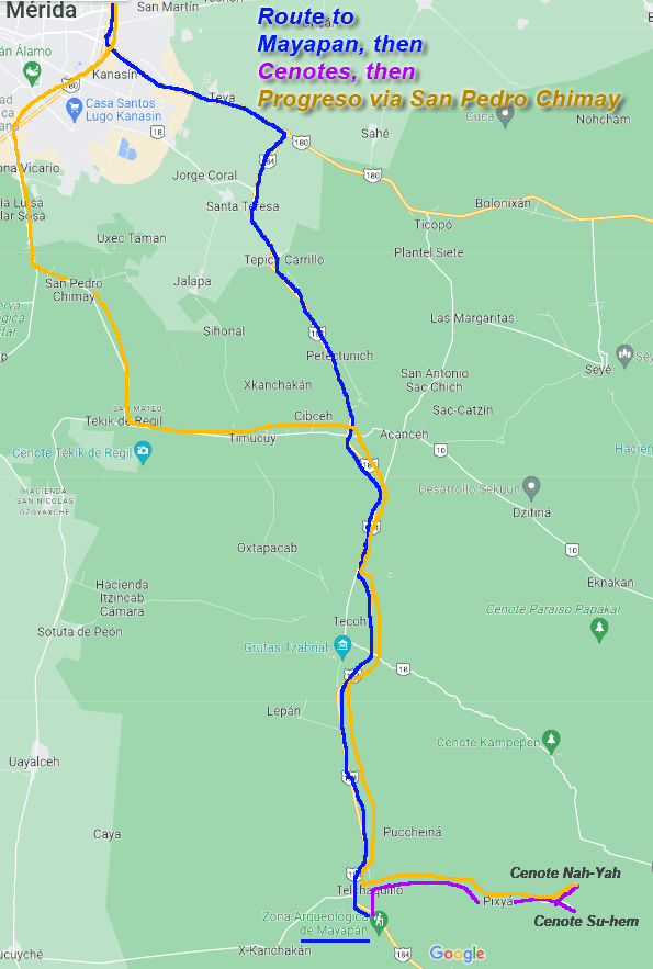
Here’s the map!
The Blue line takes you via the Merida-Cancun Highway to the Chetumal Highway, south to Mayapan.
The Purple line is the short drive to the cenotes.
The Gold line shows our route back via Timucuy, Tekik de Regit and San Pedro Chimay. (We may make this our usual route to that region from now on.)